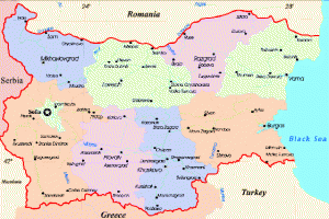
bulgaria-map
Situated in southeastern Europe, Bulgaria occupies the northeastern part of the Balkan Peninsula. To the North, via the Danube River, it borders on Romania, to the West – on Serbia and Montenegro and on the Former Yugoslav Republic of Macedonia. To the South its neighbors are Greece and Turkey. To the East Bulgaria touches the Black Sea, which links it also to Russia, Ukraine, and Georgia. The Black Sea borderline is 378 km (240 miles) long. The country’s total territory is 111 000 sq. km (43 000 sq. miles).
Location: Southeastern Europe, bordering the Black Sea, between Romania and Turkey
Geographic coordinates: 43 00 N, 25 00 E
Population: 7.8 million
Area:
total: 110,910 sq km
water: 360 sq km
land: 110,550 sq km
Capital: Sofia, 1,5 million citizens
Border Countries: Greece, Macedonia, Romania, Serbia and Montenegro, Turkey
International airports: Sofia, Varna, Burgas
Coastline: 354 km
Visas: citizens of most European countries can stay 30 to 90 days without a visa.
Currency: Bulgarian Lev (approx. 0.51 EUR)
Climate: temperate; relatively cold winters; hot and dry summers
Winter time: GMT +2 hours (October through March)
Summer time: GMT +3 hours (April through September)
Terrain: mostly mountains with lowlands in north and northeast
Lowest point: Black Sea – 0 m.
Highest point: Musala peak at Rila mountain – 2925 m.
Natural resources: bauxite, copper, lead, zinc, coal, timber, arable land
Electricity: 220V, 50 Hz
Weights & measures: Metric
Tourism in Bulgaria: 8 million visitors per year
Tags: Bulgaria map. Bulgaria city maps. Sofia Map. Bulgaria borders. Bulgaria frontiers. Bulgaria cities. Bulgaria Geography. Phiscal Map of Bulgaria. Political Bulgaria Map.


